
Walk a Renton Street Record
A sound Renton address search begins with the map, not a name. King County and city systems are parcel-centered. The parcel, meaning a mapped unit of land with its own tax identifier, is the durable link among an address, an assessor report, and recorded deeds. This order also reduces false matches when the same street name occurs in more than one jurisdiction.
- Enter the full address in the King County Parcel Viewer. Compare the map point, situs address, ZIP, legal description, and boundary when more than one result appears.
- Open the linked assessor report. Save the ten-digit parcel number, physical address, ownership field if shown, mailing address, values, sale history, and report date.
- Check city status in Renton COR Maps. Turn on city and county boundaries and confirm that the jurisdiction field says Renton.
- Take the parcel number to Landmark Web. Review deeds and other instruments by parcel, party, date, document type, or legal description.
- For an older household, compare a dated street section from a city or telephone directory. Cite the year, edition, page, and abbreviations.
This street directory sequence produces roles, not one master roster. The assessor may show a tax owner or mailing contact. A deed names parties to a recorded instrument. A directory captures a printed listing in one edition. Keep those labels intact.
Renton Parcel Fields by Address
The assessor and map tools expose different controls. The King County Assessor links eReal Property, eSales, downloads, and eMap. The separate owner-name research service is public, but the current overview does not confirm a stand-alone online owner-name input. Call the assessor at 206-296-7300 when a name-led search cannot be completed through the parcel report.
| Map field | Input | Needed | How it helps |
|---|---|---|---|
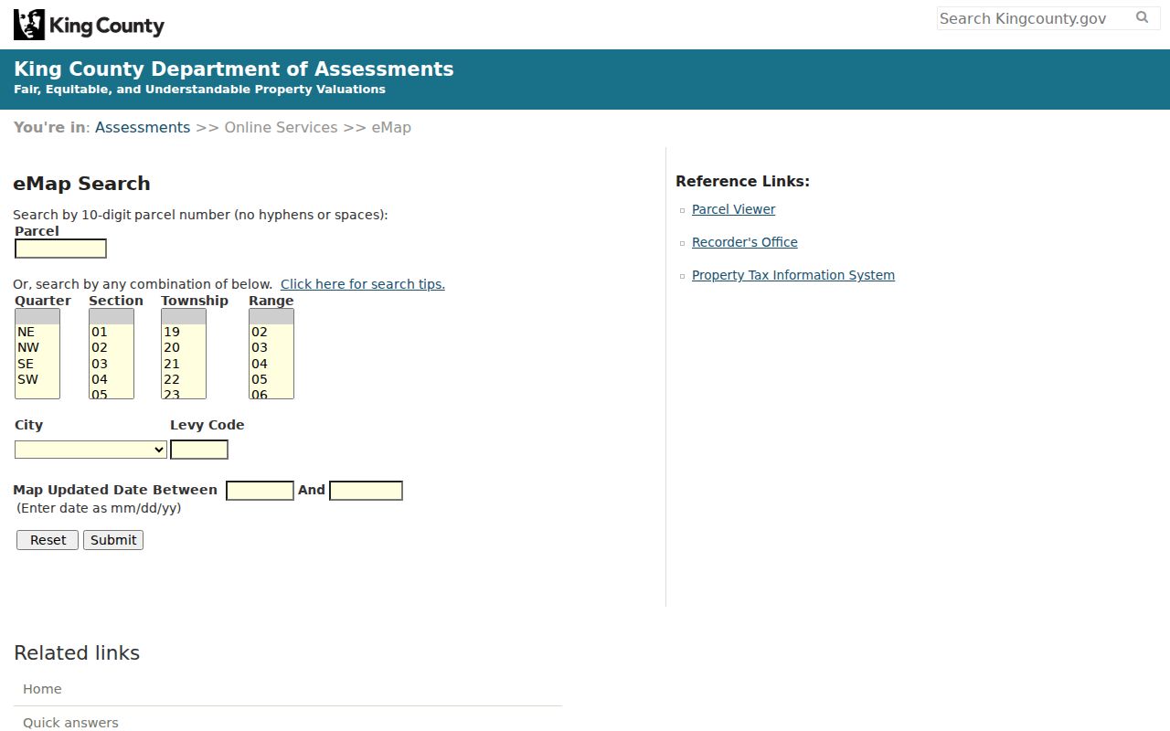
| Parcel number | Text | Optional | Ten digits without spaces or hyphens in eMap |
| Quarter, section, township, range | Select or text | Optional | Finds land through the public land survey system |
| City levy code | Text | Optional | A four-digit tax area code, not a ZIP code |
| Map updated between | Date range | Optional | Limits maps by update date |
| eReal Property | Result link | After match | Opens the detailed tax-account report |
| eSales | Result link | After match | Shows available sale history |
Open the live King County eMap to see the actual interface. Its fields show why levy code, parcel number, and ZIP should never be treated as interchangeable address keys.
Check Renton Street Jurisdiction
A Renton postal label is not proof that the parcel lies inside the incorporated city. City right-of-way and police instructions direct users to search the address or parcel, zoom to the parcel, right-click it, choose What’s Here, select the city and county boundary layer, and look for Jurisdiction: RENTON. That field determines whether a city permit, police, or utility request belongs with Renton.
The distinction matters on streets near annexed or unincorporated areas. ZIP codes and area codes may remain stable after a municipal boundary or emergency-service address changes. If the jurisdiction is not Renton, preserve the postal label but route the record request to the county or correct city.
Map rule. Cite the layer name and retrieval date. A map is a current geographic statement, not proof that a named person occupies the parcel.
Renton Street Directory Sources
Each address-keyed source has a separate keeper and date boundary. A useful Renton street directory ledger preserves both. It also shows where the online path ends and a phone call, appointment, mail form, or archive request begins.
| Address evidence | Keeper | Date reach | What it can show |
|---|---|---|---|
| Parcel and situs | King County Parcel Viewer | Current dynamic map | Parcel ID, legal description, nearby parcels, jurisdiction |
| Assessed-property report | King County Assessor | Current system; history varies | Owner field if shown, mailing and situs addresses, value and sales fields |
| Recorded instruments | King County Recorder | Generally August 1, 1991 onward online | Grantor, grantee, instrument type, date, number, parcel links |
| Older instruments | King County Archives | 1853 through July 31, 1991 microfilm | Older deeds, plats, mortgages, easements, and legal descriptions |
| City permits and cases | Renton Permit Services | Dynamic portal and map layers | Address, type, date, status, and public applicant fields |
| Historic house cards | King County Archives | About 1937 to 1972 | Possible photo, footprint, construction, sales, and assessment clues |
| Printed directories | State Library, KCLS, Museum | Edition-specific | Names or telephone listings at a printed address |
Tax situs means the physical property address. The mailing address is where tax correspondence goes and can belong to a trustee, estate, business, or representative. A plat is a recorded map dividing land into lots and blocks. A criss-cross directory reverses the usual surname order by listing entries under streets and house numbers.
Follow Renton Deeds by Street
Landmark Web is indexed by party, parcel, recording data, book and page, and legal-description terms. It is not a direct street-address search. The street directory method translates the address to a parcel ID first. County tips say parcel searching generally reaches 1997 forward, even though most online documents begin on August 1, 1991. For the 1991 to 1996 interval, also search party names, legal descriptions, dates, and document types.
Read the instrument role with care. A grantor gives or transfers an interest, while a grantee receives one. A deed may transfer title, but a deed of trust, reconveyance, easement, covenant, or lien serves another purpose. Capture the recording number, date, parties, parcel or legal description, page count, image status, and any redaction notice. Online images are unofficial and may be watermarked.
For an authoritative copy, use the Recorder’s online, mail, or in-person copy channels. For pre-August 1991 material, contact King County Archives. Bring the legal description, former owner, date range, plat, and any old street name. The research room has microfilm readers and scanners, and an appointment is recommended.
Note: A recorded instrument identifies parties to that document; it does not establish who sleeps at the address now.
Read Renton Permits by Address
Renton Permit Services and the city’s permits-and-construction layers add event dates to a parcel. Building permits, code cases, land-use notices, and right-of-way work can explain a new address, parcel split, demolition, or major alteration. Public results may include an address, case number, category, status, dates, and applicant or contractor role where that field is not restricted.
A permit name is not an occupant label. It may identify an owner, applicant, contractor, architect, or agent. Code-compliance material also has redaction limits, and reporter identity may be withheld. When a portal does not return the needed public record, use the City Clerk’s public-records request route with a narrow address, case type, and date span.
Decode Old Renton Street Names
King County adopted road-numbering resolutions in 1920 or 1921, again in 1930, and in 1956. Named roads could remain where terrain or an unusual alignment justified them. The Archives road guide connects former and new street names through resolutions. Preserve the old printed form as a search alias instead of silently replacing it.
The 2008 Benson Hill annexation supplies a distinctly Renton example. Most of one road used 116th Avenue Southeast, while a short northern segment used Edmonds Avenue Southeast and could be confused with Edmonds Avenue Northeast. A city document said six homes, churches, and small businesses were affected. Search both road forms, then compare the parcel and jurisdiction.
Black River is an older map problem. The Montlake Cut era and the river’s drying changed waterways and industrial land near Renton. A directory or newspaper may identify a rail, plant, or waterway landmark that looks wrong on a modern street map. Move from that old wording to plat, lot, block, and legal description.
Renton House Cards Add Detail
For a property from about 1937 through 1972, ask Archives whether a Real Property Record Card survives. These cards may include a building photograph, construction facts, footprint, sale clues, and assessed values. Request by parcel or legal description. That is more precise than asking staff for a broad property history.
The card links a structure to a dated assessment record, not necessarily every person who lived there. Compare it with a directory edition or deed only after checking that the legal description and parcel lineage match. Historic parcels can split, merge, or receive a new street number.
Browse Renton Streets in Print
A historical Renton street directory can fill the gap between a mapped parcel and a named household. In the street or criss-cross section, copy the target number, adjacent numbers, business or household label, surname, initials, phone, apartment, owner or renter mark, and any cross-reference. Photograph or transcribe the abbreviation key first.
Repeat the check in the next available edition. A blank line can reflect a missing volume, a household without a listed phone, changed numbering, a new building, or an editorial omission. The complete historical shelf and its year runs are covered in the Renton city directory collection; the address task here is limited to reading the street section.
Limits of Renton Street Records
No official source promises a complete list of every person at every house. Parcel geometry can describe land. The assessor can report a tax owner. Recorded documents can identify parties. A voter lookup or directory edition covers only the people and fields allowed in that system at that date. Apartments, group sites, common areas, and business parcels make a one-name-per-address claim especially weak.
Washington’s Address Confidentiality Program can substitute an address for qualifying survivors and protected professionals. A missing or substitute address must not be reverse-engineered through deeds, maps, voter information, or another person’s record. Keep searches focused on lawful family history, estate work, seller verification, civic questions, or property research.
Lawful use. Renton street records may be used for legitimate personal research. Using them to stalk, harass, intimidate, or harm a person is prohibited.